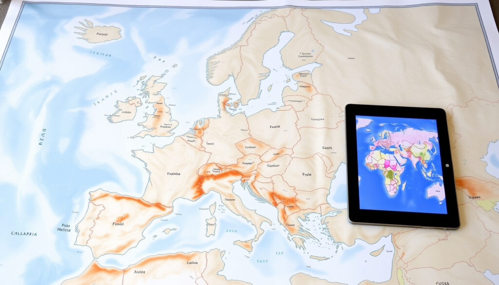
Map of Europe with Countries: Political, Physical & Interactive
You know the feeling: you’re trying to place a country, check a border, or find a capital, and the map in your head gets a little fuzzy in Europe’s political landscape of 47 countries, from sprawling Russia to Vatican City’s tiny 0.44 km². This guide cuts through the complexity, showing you exactly what a map of Europe with countries looks like—and how to get the right one for your needs.
Countries in Europe (recognized): 47 ·
European Union member states (2026): 27 ·
Largest European country (total area): Russia (partially in Europe) ·
Smallest European country: Vatican City (0.44 km²) ·
Highest mountain in Europe: Mount Elbrus (5,642 m)
Quick snapshot
- Shows country borders, capitals, and major cities (Mapsofworld (geography reference))
- Mountains, plains, rivers, and elevation shading (GIS Geography (geography education))
- Zoomable, clickable, customizable labels; integrates with Google Maps (Nations Online Project (civic atlas))
- PDF and JPEG formats, including blank outlines with capitals (Alabama Maps (university cartography))
The table below shows a continent of extremes: at one end, a dozen microstates; at the other, a transcontinental giant whose European footprint alone dwarfs entire regions.
| Attribute | Value |
|---|---|
| Total Number of Countries | 47 (44 fully recognized + 3 transcontinental) |
| European Union Members | 27 (as of 2026) |
| Largest Country by Area (European part) | Russia (approx. 3.96 million km² in Europe) |
| Smallest Country | Vatican City (0.44 km²) |
| Highest Point | Mount Elbrus (5,642 m, Russia) |
| Lowest Point | Caspian Sea coast (-28 m) |
| Population (estimated) | 740 million (Mapsofworld (geography reference)) |
| Total Area | 10,180,000 km² |
| Longest River | Volga River (3,692 km) |
| Largest Lake | Lake Ladoga (17,700 km²) |
The table reveals a continent of extremes: at one end, a dozen microstates; at the other, a transcontinental giant whose European footprint alone dwarfs entire regions.
What is a political map of Europe with countries?
A political map of Europe does one job clearly: it draws the lines. Country borders are the main visual—colored polygons that show where one sovereign state ends and another begins. Capital cities get a special marker (often a star or a bold dot), and major cities are labeled so you can orient yourself.
- Europe has 47 recognized sovereign states, including transcontinental countries like Russia and Turkey (Nations Online Project (civic atlas)).
- The map typically shows the full boundary of each country, including overseas territories where relevant.
- Political maps rarely show elevation; they prioritize administrative divisions.
What this means: if you need borders, capitals, and city names, a political map is your starting point. For mountains and rivers, you’ll want a physical map instead.
The implication: political maps serve as the essential tool for understanding the continent’s administrative skeleton.
A political map is the single most reliable tool for travelers, students, and business analysts. Without it, “crossing into Belgium” remains an abstraction. With it, you see the corridor from Amsterdam to Brussels in one glance.
Which cities on a map of Europe are most commonly featured?
Every reputable map of Europe highlights the same core set of cities. These are the political, cultural, and economic anchors of the continent.
- Major capitals: London, Paris, Berlin, Rome, Madrid, and Moscow are almost universally labeled (GIS Geography (geography education)).
- Capital cities are marked with a star or capital label; secondary cities appear in smaller type.
- Port cities (Rotterdam, Hamburg, Marseille) and cultural hubs (Barcelona, Vienna, Prague) are also featured on detailed maps.
- Some maps include regional seats like Munich, Milan, and Lyon.
The implication: if you’re looking for a small village, you need a specialized regional map. But for the major arteries of European travel and commerce, these cities are the constants.
What are the countries and capitals on a map of Europe?
A full list of 44 fully recognized European countries and their capitals forms the backbone of any serious map. Transcontinental countries—Russia, Turkey, Kazakhstan, and Azerbaijan—are included with their European capitals marked.
The countries: Albania (Tirana), Andorra (Andorra la Vella), Austria (Vienna), Belarus (Minsk), Belgium (Brussels), Bosnia and Herzegovina (Sarajevo), Bulgaria (Sofia), Croatia (Zagreb), Cyprus (Nicosia), Czech Republic (Prague), Denmark (Copenhagen), Estonia (Tallinn), Finland (Helsinki), France (Paris), Germany (Berlin), Greece (Athens), Hungary (Budapest), Iceland (Reykjavik), Ireland (Dublin), Italy (Rome), Kosovo (Pristina), Latvia (Riga), Liechtenstein (Vaduz), Lithuania (Vilnius), Luxembourg (Luxembourg City), Malta (Valletta), Moldova (Chisinau), Monaco (Monaco), Montenegro (Podgorica), Netherlands (Amsterdam), North Macedonia (Skopje), Norway (Oslo), Poland (Warsaw), Portugal (Lisbon), Romania (Bucharest), San Marino (San Marino), Serbia (Belgrade), Slovakia (Bratislava), Slovenia (Ljubljana), Spain (Madrid), Sweden (Stockholm), Switzerland (Bern), Ukraine (Kyiv), United Kingdom (London), Vatican City (Vatican City).
Dependencies and territories—such as Gibraltar (UK), the Faroe Islands (Denmark), and Åland (Finland)—are often included but marked with distinct shading or brackets (WorldAtlas (atlas publisher)).
The pattern: every country has a capital, but not every listed polity is a fully sovereign state. The map’s legend usually clarifies which are United Nations members versus dependent territories.
How can I use Google Maps to see European countries and cities?
Google Maps is the easiest way to get an interactive experience of Europe’s geography. Open the app or website, and the continent fills your screen—no download required.
- Open Google Maps and zoom into the European continent using the scroll wheel or pinch gesture.
- Use the search bar: type “Italy” or “Paris” and Google Maps jumps directly there, showing the country outline or city streets.
- Toggle between satellite, terrain, and political layers by clicking the “Layers” icon. The satellite view shows physical geography; the default view shows political boundaries.
- For a broader view, search “Europe” and let Google Maps center the entire continent.
The trade-off: Google Maps is powerful for navigation but less helpful for seeing the whole continent at once. It’s a window, not a poster. For a full, printable map of Europe with countries, you’ll need a static source.
The catch: use Google Maps for orientation, not for a comprehensive overview of the continent’s political layout.
Where can I find a full map of Europe?
Reliable full maps of Europe come from established geography sources. Each is optimized for a different use case—whether you need a classroom wall map, a PDF for a handout, or a fully interactive tool.
- Ontheworldmap offers a Europe map with capitals that users may download, print, or use for educational, personal, and non-commercial purposes (Ontheworldmap (map reference)).
- GIS Geography provides a Europe map that displays countries, capitals, and physical features, plus reference maps for each country (GIS Geography (geography education)).
- Alabama Maps (University of Alabama) hosts Europe maps in black-and-white PDF and JPEG formats, including versions for countries and for capitals and major cities—ideal for printing (Alabama Maps (university cartography)).
- Mapsofworld offers a political map showing geographical boundaries, national capitals, and primary cities, with an estimated population of 740 million for the continent (Mapsofworld (geography reference)).
- Nations Online Project provides a political map that distinguishes EU member states, non-member states, and EU candidates, plus the location of country capitals and major cities (Nations Online Project (civic atlas)).
- WorldMapBlank markets a labeled political map of Europe as free (WorldMapBlank (blank map resource)).
For educators and students, Alabama Maps (Tier 1, university source) is the most authoritative choice for downloadable files. For a quick reference that includes EU vs non-EU status, Nations Online Project gives the clearest breakdown.
If you’re a teacher preparing a lesson on European geography, skip the Etsy listings. Use Alabama Maps for free, high-resolution PDFs that print cleanly. For a classroom wall display, Ontario’s TheMapStore or geology.com offer premium laminated political maps. For students: GIS Geography and Ontheworldmap are free, tier-2 sources that require no registration.
Confirmed facts
- Europe consists of 47 sovereign states including transcontinental countries.
- The European Union has 27 member states as of January 2026 (Nations Online Project (civic atlas)).
- Mount Elbrus is the highest peak in Europe at 5,642 meters (Mapsofworld (geography reference)).
- Vatican City is the smallest country in Europe (0.44 km²) (Mapsofworld (geography reference)).
- Ukraine is the largest country entirely in Europe (603,500 km²) (Mapsofworld (geography reference)).
- Free printable Europe maps are available from university and atlas sources.
What’s unclear
- The exact number of countries can vary depending on inclusion of disputed territories (e.g., Kosovo, Abkhazia).
- Some definitions consider Cyprus as part of Europe despite its geographic location in Asia.
- Not all map providers agree on the status of transcontinental countries’ European boundaries.
- Europe’s longest river and largest lake are subject to different definitions across sources.
For travelers and researchers, the political map remains the foundation—but the edges of Europe are still open to debate.
Related reading: Europe political map · Map of Europe with capitals
For a quick reference, you can also consult this labeled and printable map of Europe that includes country names and capitals.
Frequently asked questions
How many countries are in Europe?
There are 47 recognized sovereign states in Europe, of which 44 are fully recognized and 3 are transcontinental (Russia, Turkey, Kazakhstan).
What is the smallest country in Europe?
Vatican City is the smallest country in Europe, with an area of 0.44 km².
Is Russia considered part of Europe?
Yes, Russia is considered a transcontinental country. Approximately 4 million km² of its territory lies in Europe, and its capital Moscow is in Europe.
What is the highest point in Europe?
Mount Elbrus in Russia, at 5,642 meters above sea level, is the highest peak in Europe.
Which European country has the largest population?
European Russia has the largest population of any European region, followed by Germany and the United Kingdom.
What is the difference between a political map and a physical map?
A political map shows country borders, capitals, and cities. A physical map shows elevation, mountains, rivers, and natural features.
Can I download a printable map of Europe for free?
Yes. Alabama Maps (university source) offers free black-and-white PDF and JPEG maps of Europe with countries and capitals.
More related posts
 Ashlee Simpson: SNL Incident, Career, and Family Life
 Trisha Paytas Baby Names: Malibu, Elvis & Aquaman Moses
 Pierre Poilievre Carbon Tax – Stance, Plan and Debate Explained
 The Dark and the Wicked – Plot, Ending, Cast Explained
 CRA 2026 Tax Season Changes – Key Dates and New Rules
 How Many ml in a Cup? US, Metric, UK Conversions Compared
 Tickets 2021 Sites for Gamification Summit: Guide